

Carrying out pre-drill profiling at cowieslinn quarry
The first step in drilling and blasting.
At R.J. Blasting we use the best survey and scanning equipment to ensure we give our customers the best results. Our surveyors/profilers use Renishaw/Carlson and MDL Face Laser Scanners and Leica GPS Equipment to pinpoint the position of every single blast hole in a blast.
The Leica GS16 is a powerful self-learning GNSS smart antenna. The growing number of signals from ever-increasing satellite constellations demands the GNSS receiver to be smart and reliable. The GS16 is a solid measurement companion for surveyors who need a survey-proof GNSS system that is light to carry anywhere but handles even the most challenging measurement conditions. The GS16 is a smart solution – Use it as a rover or as a trustworthy base. Tracking multi-frequency signals comes as standard with all Leica Geosystems GS sensors. Combined with an excellent GNSS antenna element and a position update rate of 20 Hz, GS16 ensures reliable measurement quality.

hole data with 3d aerial drone scan data overlay at drakelands mine.
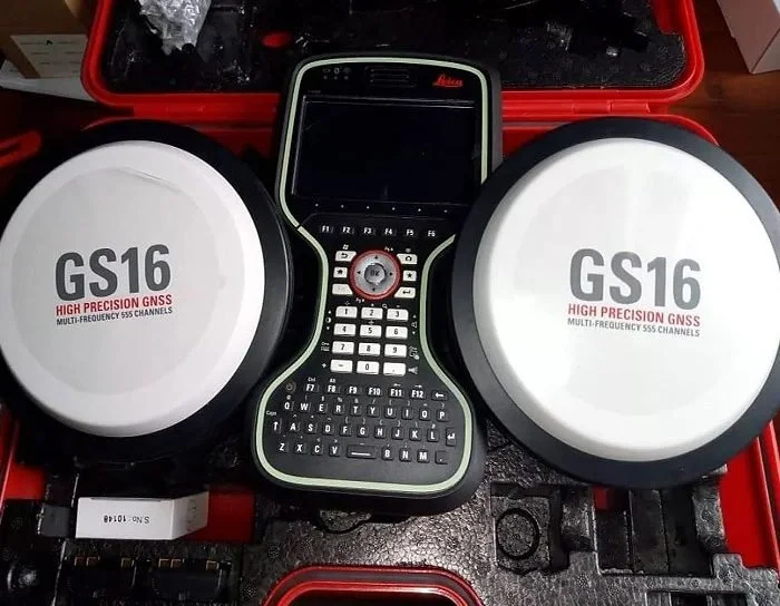
lEICA VIVA GS16 GNSS.
3D modelling software allows accurate measurements of all parameters of the blast to ensure optimum results each and every time. Our software allows information to be exported in various formats for use by clients and by our own shotfirers ensuring the accuracy of our work is carried through to the final phase in blasting operations.

3D design data for installation of slurry tank near biggar, lanarkshire
We are also able to check post drill hole deviation using BORETRACK© Hole probes. This allows us to measure true hole burdens and azimuths in particular rock types that give rise to deviation in the first place. These measurements will be linked to GPS produced face profiles allowing the true path each hole has taken while being drilled to be documented.
